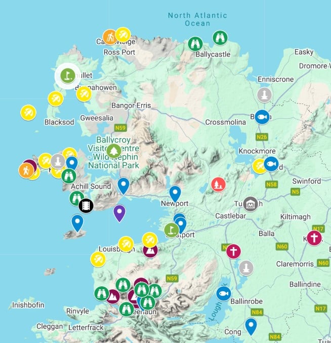
I have created an interactive map of County Mayo, including its main attractions, scenic locations, historical sites, towns and villages.
It’s the first and most comprehensive interactive visitors’ map to county Mayo you’ll find online. It has also been a labour of love and I plan to add plenty more points of interest over the next months.
About My County Mayo Map
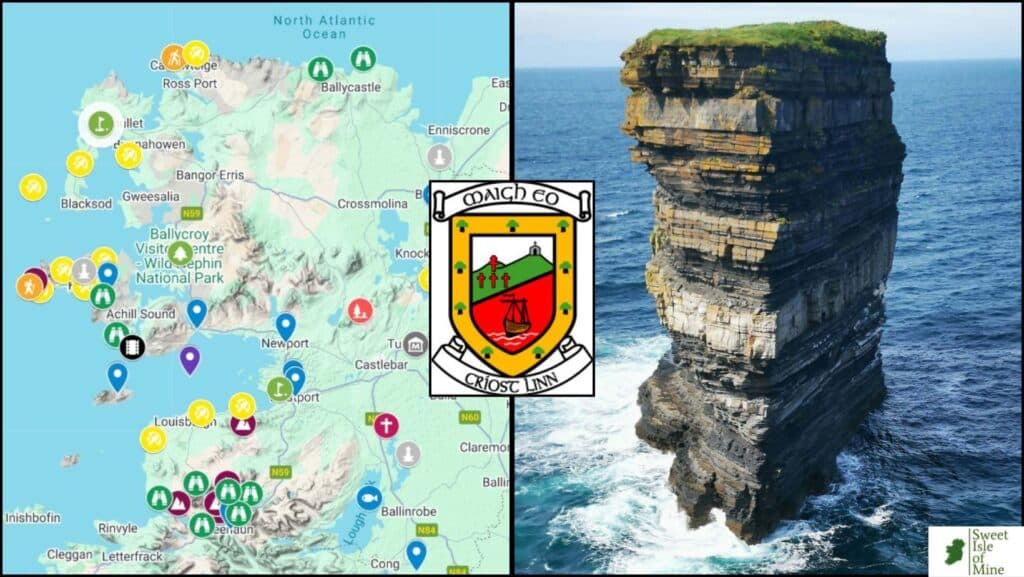
Here’s an image of the map I’ve put together. But first, let me point out some things before you come to the interactive version further on in this article.
It’s completely free to use
No paywall, no ads, no nonsense; just some good ol’ local tips to make sure you get the most out of your trip to county Mayo. Added to that, almost ALL attractions listed on the map are free of charge to visit.
There’s both well-known attractions and some proper hidden gems
Ireland’s most climbed mountain, Croagh Patrick, as well as one of the world’s magnificent beaches at Keem have inevitably been mentioned, but I’ve also included locations such as the Glenummera valley and nearby peaks of Ben Gorm and Creggan. You’ll see these locations seldom mentioned on any guidebook, but for me, they are the essence of County Mayo.
Each point of interest has direct links to dedicated articles
By clicking on each pointer you will see a link. By clicking on this link, you will be directed to one of my detailed articles about this location.
You may also be directed to an article in which the location is included. For example, we talk about Lough Mask in our article about the ’10 best places to explore in County Mayo’.
You’ll find various categories colour coded with logical symbols
It’s all pretty self-explanatory, peak symbols for mountains of interest, blue markers for towns etc. More on this a little later.
You’ll notice a high concentration of markers in certain locations
The western seaboard of Mayo is the most scenic as the region in blessed with magnificent cliffs, beaches, island and spectacular mountain landscapes.
However, further inland, you’ll find the Museum of Country Life, an attraction which is free of charge and a wonderful insight into life in the west of Ireland in days gone by. Also, don’t overlook the magnificent region of North Mayo, as it is home to some of Ireland’s wildest and most spectacular coastal scenery. The fishing town of Ballina, with its excellent summer salmon festival is also well worth a visit.
The Markers Explained
Blue Location Pointers
They represent the best towns and bases I recommend staying in to get the most out of your trip. For example Westport, although very popular, is perfect to explore the nearby Clew Bay, Croagh Patrick and Doolough Valley. It also offers some of the west of Ireland’s best cuisine, pubs and a variety of accommodation options.
There are numerous other great bases to explore the surrounding areas, such as the beautiful coastal village of Mulranny, with views over Clew Bay, and located right on the Great Western Greenway cycle path.
Purple Peak Markers
These represent the mountains I have personally climbed and can recommend highly. All offer a good challenge too. As unassuming as most mountain are in County Mayo, with the highest (Mweelrea) only reaching a height of 814 metres, the hikes are not to be sniffed at.
I recently took on the twin peaks of Ben Gorm and Ben Creggan, a view that will live long in my memory. The Cliffs of Croaghaun on Achill are a sight to behold. Perhaps Ireland’s most spectacular coastal landscape.
Yellow Beach Markers
These repersent my choice of County Mayo’s best beaches. Bertra, Old Head, Keem and Keel are all covered in detail so just click on the marker and you’ll be directed straight to my posts. The others have been included in a round up post of my 15 favourite beaches in the county.
Green Binocular Markers
These are my choice of the most scenic places in the county, places where you get to witness the beauty up close and personal. Some highlights include the Atlantic Drive on Achill Island, as well as the unforgettable view from Minuan Heights.
Some of my favourite locations such as the Sheeffry Pass are also included as well as the unique sea stack at Downpatrick Head.
Orange Walking Markers
These represent some of my favourite moderate hikes in the County, including the magnificent coastal walk at Carrowteigue in North Mayo. More to follow over the next months.
Black Movie Markers
These symbols represent locations where some iconic movies were filmed in County Mayo. Many of you will be familiar with the Banshees of Inisherin, but did you know most of it was shot on Achill Island? We provide the original and most comprehensive guide to these locations.
You’ll find other locations plotted too, namely for the Quiet Man and The Field.
Magenta Cross Symbols
These markers represent areas of religious significance in the county, the 2 main locations being the 13th century Ballintubber Abbey, as well as the Marian Shrine at Knock.
Green Golf Markers
Carne Golf Links is widely regarded as one of the world’s greatest, while Castlebar offers beautifully maintained surroundings. Mulranny golf club allows the local sheep to maintain the fairways!
Blue Fishing Symbols
It’s no secret that Mayo has a reputation for some of the best fishing in Europe. Ballina is iconic for its Ridgepool, while Lough Mask is home to the annual world trout fishing championship. Don’t overlook deep sea fishing off Mayo’s immense coastline.
Grey Historical Monument Symbols
Mayo is full of historical sites, be it the melancholic Deserted Village on Achill or the magnificent friary at Rosserk. A drive through the countryside will reveal countless other ancient sites, such as the Ceide Fields. Mayo, in fact, has the highest concentrarion of ancient sites in the country.
My County Mayo Map
Questions about County Mayo
Here are the most common questions I have been asked about County Mayo down through the years.
What are the main towns in County Mayo?
Castlebar (pop. 13,054) Castlebar is the county town of County Mayo
Ballina (pop. 10,556)
Westport (pop. 6,872)
Claremorris (pop. 3,857)
Ballinrobe (pop. 3,148)
Ballyhaunis (pop 2,773)
What are some interesting geographical & historical facts about County Mayo?
Mayo’s coastline has a length of 1,168 km (726 mi), making it the county with the longest coastline in Ireland.
Clew bay, located near Westport, is famous for its 365 islands, often said to represent one island for each day of the year. It’s a unique and picturesque feature of Mayo’s coastline.
Ireland’s highest cliffs, and some of Europe’s highest are found on Achill Island. They are named Croaghaun and reach a height of 688 metres. Nearby Keem Beach is widely regarded as one of the world’s most beautiful strands.
Mayo is traversed by numerous rivers, with the River Moy being the most significant. It is renowned for its salmon fishing and is a major tributary to the Atlantic.
Mayo is home to Connacht’s highest peak, Mweelrea, at a height of 814 metres.
Mayo is home to Ireland’s only true fjord, Killary.
Mayo is dotted with ancient stone circles, burial mounds, and Neolithic monuments. One notable site is the Ceide Fields, which contain the oldest known field systems in the world, dating back over 5,000 years.
The county is home to the Ballycroy National Park, one of the largest areas of bogland in Europe. It’s a designated Special Area of Conservation and is also a designated Dark Sky Park.
Conclusion
I hope my map can help you plan your trip to County Mayo. As time goes on, I will add more locations, but I do feel there is more than enough to help you whittle down exactly where to visit. My tip is to rent a car and just explore this magnificent county. I have spent my life here and still stumble across hidden gems at ever corner. Happy planning!